BRUCEDALE – Guelph/Eramosa council is recommending a smaller lot severance than requested in response to a severance application that would see boundaries changed on two adjacent agricultural properties.
“We’ll be supporting the staff-proposed lot lines, not the original,” township Mayor Chris White said during the May 21 council meeting.
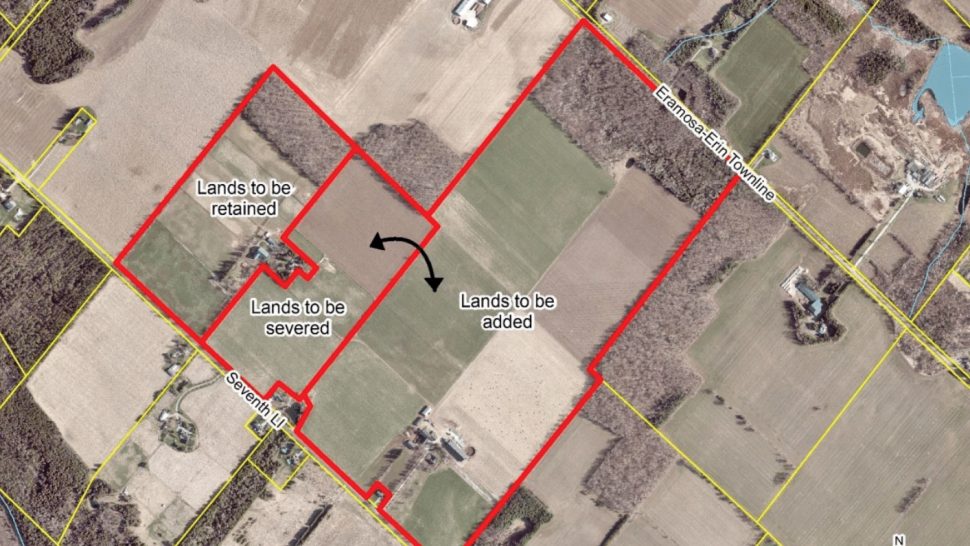
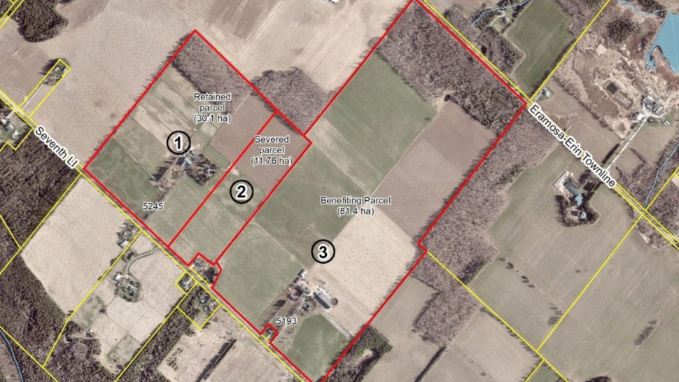
This was after having seen two maps — one showing the new lot lines proposed by applicant E and J Real Estate Holdings Inc., and the second showing modified boundaries suggested by the County of Wellington’s planning and development department.
According to the department’s report, E and J Real Estate Holdings has asked to sever approximately 19.2 hectares (47.44 acres) of vacant agricultural land from 5245 7th Line, and add it to the abutting agricultural parcel at 5193 7th Line.
The result would be a shifting of the lot lines, changing the size of the first property to 22 hectares (54 acres), and increasing the size of the second property from 80 ha to approximately 100 ha (247 ac).
A house, barn, shed, drive shed and horse run-in would remain on the smaller property, and the applicant has also requested an easement for an existing hydro line. The larger property also has a dwelling and barns.
It’s not clear from the report why the applicant is seeking to sever the land.
“It is understood that the intent of the lot line application is to make the abutting agricultural parcel large,” the report states.
But the county is suggesting severing a lesser amount of land in order to keep lot lines regular.
The first map included in the report shows the applicant’s proposed severance, which draws an irregular box around the buildings on the first farm.
The second map shows planning staff’s proposal, with the boundary being a straight line along the southeast side of the farm’s buildings.
The difference is about eight hectares more that would be retained with the first farm.
The justification provided in the report is a stipulation in the county’s official plan that states “all new lots shall have logical lot lines given existing lot patterns in the area, natural and human-made features and other appropriate considerations.”
Both properties are designated “prime agricultural, core greenlands and greenlands” within the county’s official plan, with identified features including significant wooded areas, provincially significant wooded areas and Grand River Conservation Authority regulated wetlands.
The lot line adjustment “is located within the prime agriculture and greenlands designation,” the report states.
The county’s official plan permits lot line adjustments where agriculture is not adversely impacted.
However, in neither the applicant’s proposal nor county staff’s amended proposal would the remaining lot meet the minimum required lot size of 35 ha for agricultural zoning. This means a minor variance would be required.
“We’re going to recommend the staff thing, because it seems cleaner,” said White, following comments from multiple councillors in favour of the straight boundary line.
“We’re not the decision maker here; we’re only passing comments on,” he added.
The application will be considered through the County of Wellington’s planning and land division committee. Should it be approved, township council will impose the following conditions:
– the satisfaction of financial requirements;
– parkland dedication;
– assurance that servicing on the retained parcel is available; and
– township zoning compliance is achieved.


