PUSLINCH – It appears CBM will have a tougher job convincing residents that extracting gravel from a pristine piece of agricultural land is a good idea than it will persuading province.
Company staff and a planning consultant from MHBC Planning held a virtual public meeting on May 8 to discuss its application for an expansion to the South Aberfoyle Pit on Concession 2, also known as the McNally Pit.
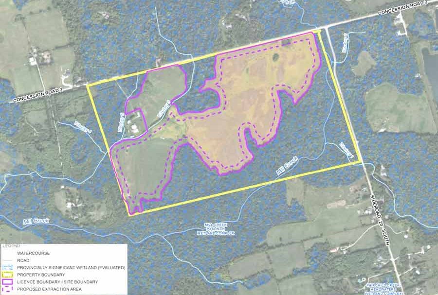
However, the 44.8-hectare (110-acre) property at 6947 Concession 2 is 2km down the road, with woodlands and a provincially significant wetland on the south and west sides, and Mill Creek and a tributary running through it.
It is designated core greenlands and greenlands on Wellington County’s Official Plan and is not located within the county’s mineral aggregate resource overlay.
It is zoned natural environment and agricultural in Puslinch Township’s environmental overlay.
As such, CBM Aggregates must apply for an official plan amendment with the county and a zoning change with the township, as well as apply for an aggregate licence with the Ministry of Natural Resources and Forestry.
The extraction area is 27.5 hectares (67 acres) and CBM plans extraction above and below the water table to a maximum depth of 25 metres.
Preliminary exploration indicates there are 5.5 million tonnes of sand and gravel on the property and officials expect it will take six to 10 years to extract it, with a maximum annual extraction rate of 1 million tonnes per year.
When it’s done, the site will become a lake about 26 hectares in size with 0.3 hectares of new wetland and 6.7 hectares of new forest created in the setback areas.
CBM officials are calling this a feeder pit as material will be taken to the McNally pit for processing.
About 20 people attended the meeting and several were concerned about calling this an expansion when it is two kilometres from the existing South Aberfoyle Pit.
“It’s misleading to the public to say it’s an expansion,” said a participant named Kathy during the question perio.
She added people assume an expansion means making an existing pit larger, not adding a new pit that is not physically connected to the McNally Pit.
“It downgrades the importance of this application,” she said.
MHBC planner Neal DeRuyter said it’s called an expansion, “because it will be operationally linked to the Aberfoyle Pit, in extraction and shipping. And it has the same requirements (in terms of environmental studies) as a new application.”
Kathy also wanted to know why the area to be licensed is bigger than the extraction area.
“There is no intention to extract in that area,” DeRuyter replied. “And the official plan and zoning applications specifically noted there will be no extraction there.”
Kathy wasn’t buying that answer, noting that in the past another pit (not a CBM pit) said there would be no extraction in a licensed area and then the zoning was changed, and the area was extracted.
“If it’s not being extracted, then it doesn’t need to be licensed,” she countered. “If it’s licensed, you could change the zoning later.
“We’ve seen it a few times. I object to this because of history.”
Mayor James Seeley attended the meeting and said he doesn’t want the McNally pit to become a central processing site for all the CBM pits in the township.
With the land in question being called an expansion of the McNally pit, he worried any future site could be considered an expansion too.
His main concern was for township roads and the inconvenience to residents due to heavy trucks rumbling through the municipality.
“Will you commit to not receiving material from outside the municipal boundary?” Seeley asked.
“We saw this property as a natural expansion of McNally,” answered David Hanratty, CBM’s director of land, resource and environment.
He added it makes sense not have processing at multiple locations.
“We look for opportunities to minimize impacts. I think it’s a wise way to do it,” he said.
Other questions had to do with personal wells and what residents can do if their wells are affected by extraction operations.
Hanratty said well monitoring is set up on the site and any low water levels “will show up at our site before yours.”
He also noted homes within a certain radius of the property can opt into the company’s well monitoring program. Base levels are taken before the operation begins and then there will be annual water monitoring reports sent to numerous agencies for review.
The proposed pit is far from a done deal. Commenting on the Environmental Registry of Ontario posting closes June 3.
Public meetings will be arranged by the county and the township when the official plan and zoning amendment proposals have been received and subject experts have gone through CBM’s studies.
In the meantime, the township has sent a letter of objection to CBM and to the ministry.


