

ELORA – The urban boundary of Elora and Fergus approved by township council in October will change in minor ways after it was revealed on March 25 that Wellington County planning staff had tweaked the boundaries to avoid farmland fragmentation.
The new recommendation increases the urban boundary previously approved by council by 42 hectares, but that is still less than the residential and employment needs in Centre Wellington that the county originally identified when it started its official plan review.
Township managing director of planning and development Brett Salmon explained the new urban boundary township council approved in October had odd little corners and indents that isolated some properties and fragmented farmland.
By shifting the lines on the map, farms could remain intact and growth will remain logical, he said.
Without those changes, “we would potentially landlock agricultural parcels,” Salmon said.
The county had initially determined Centre Wellington needed to add 398 hectares of land to its urban boundary to accommodate residential and employment growth to 2051.
By adding more density to the Fergus South Secondary Plan and on infill proposals, council was able to reduce the increase to 326 hectares, thereby saving farmland from development.
The tweaks to the boundary made by the county increase urban expansion to 364 hectares, which is more than what council had approved, “but council can still say they reduced the impact on farmland,” Salmon added.
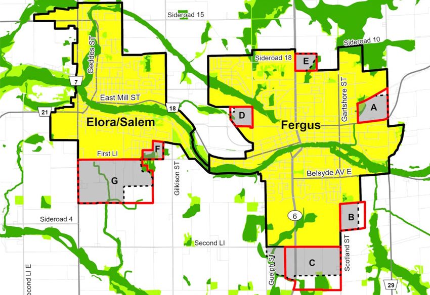
The map shows the areas of expansion and the minor changes proposed by Wellington County.
Areas A and D represent minor rounding out of the urban boundary to include small existing developed lots. Areas E and G expanded to include natural features and create logical boundaries.
Area F, on First Line in Elora, was once zoned country residential and was included in the boundary to allow small scale development. But any homes constructed here will not have municipal services, Salmon said.
Salmon also drew attention to a report from county manager of policy planning Sarah Wilhelm that originally went to the county planning committee and was included in Centre Wellington’s agenda.
In it, Wilhelm explains that as well as farmland fragmentation and landlocked agricultural parcels, staff also wanted to ensure expanding the urban boundary would not result in minimum distance separation encroachment.
“In response, the draft mapping has been revised to include additional Community Area Land in Elora/Salem (Area G) and Fergus (Area B) to eliminate remnant landlocked agricultural parcels,” she states in the report.
There was a more significant change in south Fergus in Area C, where more land was added on the east side of Highway 6 for industrial land, and some removed west of Highway 6 to reduce minimum distance separation impacts on adjacent farmland.
Salmon also noted the county has identified that there is aggregate in parts of Fergus South.
The county had proposed removing the mineral aggregate resource overlay from the urban boundary.
But Salmon said there may be opportunity for extraction to happen on the future industrial lands, given that it could be another 10 years before construction begins there.
With those explanations, council endorsed the new boundary proposed by Wellington County.