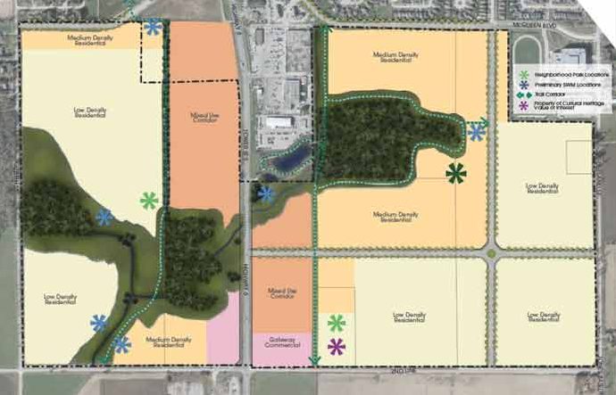
CENTRE WELLINGTON – Council came away with a clearer picture of what the South Fergus development will look like and what it will be like to live there after a special committee of the whole meeting on April 15.
But no decisions were made and councillors, township staff and the planning consultant will consider comments made at the meeting and how to incorporate new ideas and clarity into the plan.
Council was first presented with the South Fergus Secondary Plan on March 25 along with the master environmental servicing plan for the area, but wanted the opportunity to ask more questions before making such a big decision.
That’s what happened at the committee of the whole meeting on April 15: open discussion without the pressure of making a decision right away.
At an earlier council meeting the same day, council did approve the master environmental servicing plan for South Fergus, which determines where water, sewers, and stormwater retention ponds will be located on the property.
Around those services, trails, parks, open space, and connections to future roads and sidewalks are planned, making the most of these naturalized areas, managing director of planning and development Brett Salmon explained.
The land, currently vacant, stretches from 2nd Line to the existing southern edge of town and straddles Highway 6 from Guelph Street on the west to Scotland Street to the east.
It is expected to house 6,000 people and staff see an opportunity to add more density here – 55 to 60 people and jobs per hectare as opposed to the 47 people and jobs per hectare target Wellington County has set for Centre Wellington to meet its growth targets.
At the first meeting, the presentation centred around land use designations. The plan identifies areas for low- and medium-density residential, gateway commercial at 2nd Line (the new entrance to Fergus), and a mixed-use corridor on both sides of Highway 6 into town.
Dave Aston, a principal with MHBC planning consultants hired by the township for the project, explained the secondary plan is a policy for development, taking into consideration background reports and technical studies for the area.
Once the secondary plan is approved, work can physically begin on the infrastructure projects and applications can be received from developers.
That’s when council will consider zoning bylaw amendments and plans of subdivision.
“That’s when we specifically place parks, roads, setbacks, and establish housing forms,” Aston said. “And all these details need to conform with the secondary plan and official plan.”
Aston also talked about the community design guidelines, which are part of the secondary plan and spell out the vision and principles that will be considered as applications come forward.
The guidelines talk about gateway features, road design, active transportation, parks and open spaces, trails and walkways, stormwater management facilities, including pedestrian safety in street and public space designs, and guidelines for cohesive landscaping, signage, and lighting along Tower Street in the mixed-use commercial zone.
Definitions for low-density residential include townhouses, which is considered medium density in other parts of the township, Salmon said. It’s not just single-family homes in the low-density zones.
And medium-density residential could include variations of low-rise apartment buildings to creative four-plexes.
“This has been very helpful,” said councillor Jennifer Adams. “I’m starting to see a community people can live in.”
Councillor Kim Jefferson had concerns about the proposed eight-storey height that would be allowed along the mixed-use corridor and how there might be an abrupt change at 2nd Line from bucolic countryside to tall buildings.
She didn’t want the gateway to feel like a tunnel and wondered if buildings in the gateway area could be stepped back for a more gradual introduction to the building height on Tower Street.
And even while she understands and agrees with higher density, Jefferson was not comfortable with eight-storey buildings, hoping to set the limit to six storeys.
“If we decrease the density there, we’d have to look at opportunities to repatriate that density,” Aston said, adding it’s possible to “pick up the difference” by allowing more density in the low-density areas.
“We have to put the population somewhere.”
Lowering the density in the entire South Fergus Secondary Plan would add pressure to intensify in the downtowns and already established parts of the township, he said. It would also mean expanding the urban boundary into farmland.
Salmon said it would still work to lower the height of the mixed-use corridor to six storeys if density was spread through the other parts of the secondary plan, but he didn’t want to change the target of 55 to 60 people and jobs per hectare.
Councillor Denis Craddock wondered if the plan could include health facilities like a walk-in clinic or after-hours health facility.
Salmon said that kind detail is outside the scope of the secondary plan, but the definitions are broad enough that a clinic could locate on the mixed-use corridor.
Mayor Shawn Watters, who is a landscape architect by trade, said he was excited about the possibilities in the development.
He envisioned a tree-lined roadway, not a wall of buildings along Tower Street; an impressive gateway feature that heralds the arrival into town; and a unique mix of housing types to accommodate many different price points for future renters and buyers.
Density will also preserve prime agricultural land, he reminded council.
“That’s the value piece we have to keep top of mind. That is our important legacy. And we can show everyone that this is how you do it – have density but still feel like a community,” he said.
“For 21 years the township has been working toward this end. I think we are doing something wonderful here.”
Council received the presentation for information.
The South Fergus Secondary Plan will return to council for approval at a future date.


