FERGUS – Despite staff being in favour of the Fergus South Secondary Plan, council decided to hit the pause button at its March 25 meeting.
Council wasn’t convinced that public feedback had been incorporated into the plan and was concerned about the possibility of eight-storey buildings along Highway 6 at the new gateway to town.
“I do feel pressure from the province, but we have been meeting our (new home) targets,” said councillor Jennifer Adams as she put forward a motion to defer the decision.
“Taking extra time shows the importance of the issue. We want to be careful in how we proceed. And eight-storey buildings are not sitting well with me, either.”
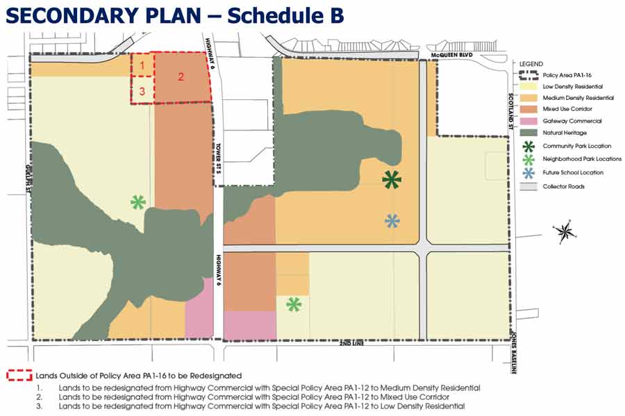
The plan for Fergus south is immense, running from 2nd Line north along Hwy. 6 to the existing stores in south Fergus and straddling the highway between Guelph Street to the west and Jones Baseline to the east.
It will draw another 6,000 people to town and will have mixed styles of housing as well as commercial and office space, roads and intersections, a school, parks, trails and green space, and water and sewer lines.
The South Fergus Secondary Plan and Master Environmental Servicing Plan were developed in tandem, making the most of existing trees and hedgerows, placing parks near stormwater ponds and trails for connectivity.
The plan determines land use and proposes areas for low-density residential (maximum three storeys), medium-density residential (maximum six storeys), and in the mixed use and gateway commercial areas, buildings could be eight storeys high, with ground floor commercial and apartments above.
The preferred watermain servicing plan has capacity to add homes on “the crescents” – Cummings, Chambers and Barnett crescents at the northwest edge of the property – should those homeowners choose to hook up to the municipal service in the future.
It also plan considers the impact on adjacent farmland to not cause flooding or drain water from those farms.
David Aston, a partner with MHBC hired by the township to prepare the document, said once the secondary plan is approved, policy and design guidelines will be completed that in turn will give direction on how the land can be developed.
He said recurring comments from public meetings were:
- for “the crescents” to be able to connect to municipal services in the future;
- for there to be connections (trails, roads and sidewalks) within the development;
- to have safe pedestrian crossings across Hwy. 6; and
- to lessen the impact of development on surrounding agricultural land.
“We heard the comments and made the changes,” Aston said.
Brett Salmon, managing director of planning and development for the township, said it’s a good plan and staff are satisfied that all the comments have been addressed.
He said Wellington County had calculated that Centre Wellington would need to add 238 hectares to its urban boundary to accommodate growth and for the Fergus South Secondary Plan to have a density of 47 people and jobs per hectare.
But the plan has 56 people and jobs per hectare, he said, and that reduces the need to expand the boundary as much, saving about 25 hectares of farmland.
“Density does make a difference,” he said. “We’re protecting farmland here.”
Once council approves the plan it will be sent to Wellington County for approval. Then the secondary plan becomes part of the official plan. And then developers can begin making applications to build.
Still, council didn’t want to jump on board too quickly.
“This will be one of the biggest decisions we’re going to make as a council,” said Mayor Shawn Watters. “We can take a couple of weeks on this.”
Council decided to defer the decision until it can be discussed at a special Committee of the Whole meeting in April, the date of which has not been decided.


